
-
Designer
Sasaki Architects
-
Client
Jurong Town Corporation (JTC)
-
Location
Singapore
-
Scale
City
-
Status
Unbuilt
-
Use
Industrial
-
Services
Ecological Placemaking, Biodiversity Survey & Impact Assessment, Ecosystem Service Assessment
-
Year
2020
Kallang Kolam Ayer Industrial District, Singapore


Project Summary
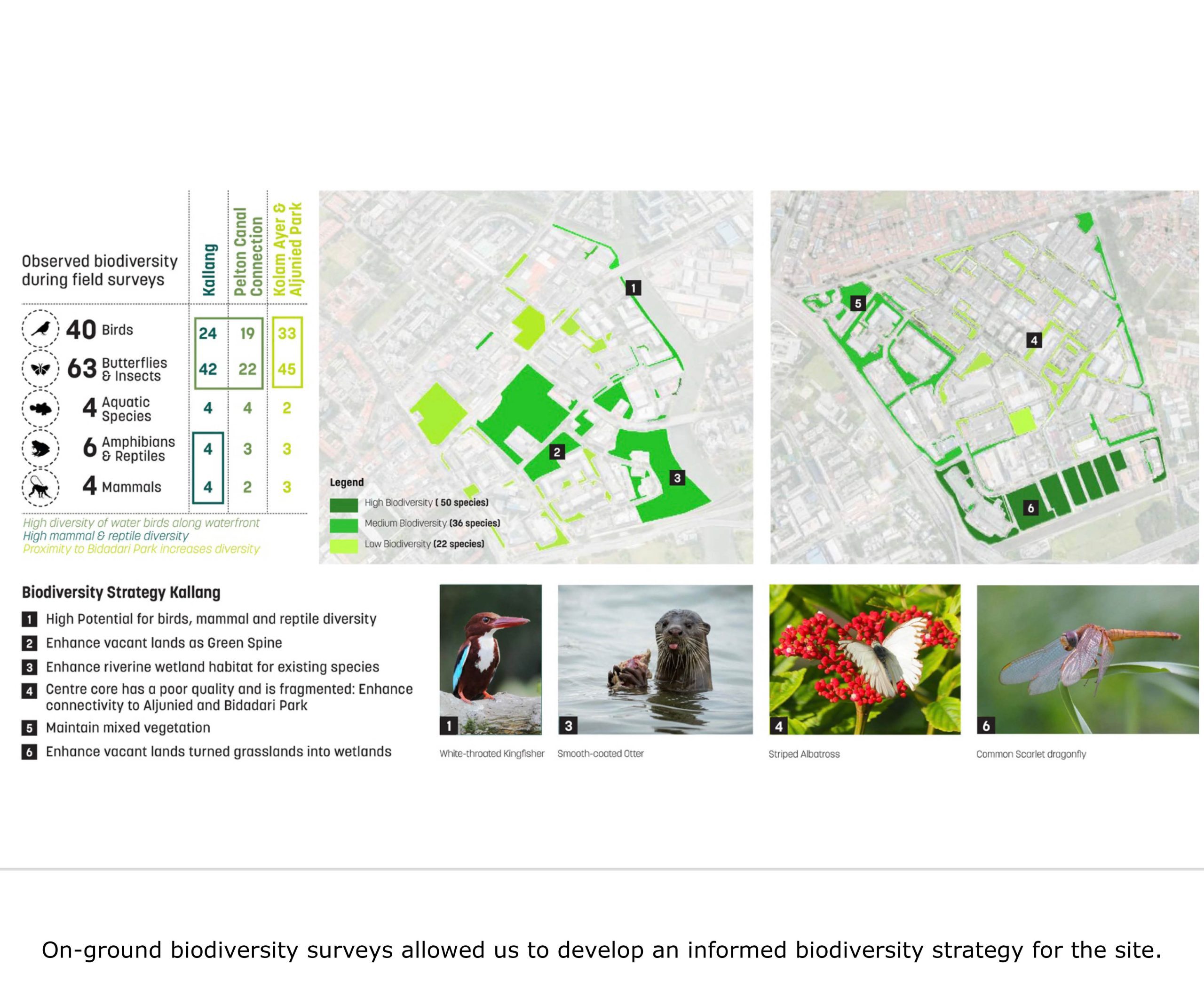
In 2020, bioSEA served as the ecological consultant for the Kallang-Kolam Ayer Innovation District in Singapore providing inputs on ecological placemaking, biodiversity and storm water management strategies. The district aimed to be part of the Industry 5.0 movement and sought to Revitalise & Realise a resilient ecosystem and meaningful landscapes.
A key intervention was to restore a water network to enhance ecological connectivity across the River Basin. This meant restoring a threatened marshland ecosystem that can attract diverse wildlife, creating a distinctive identity for the site. The site, which totalled more than 100 ha, has 2 main parcels (Kallang and Kolam Ayer) separated by the Kallang River. These could be linked through an ‘e-Corridor’ along the waterfront, offering spaces for recreation, leisure, and social gathering, while supporting ecological functions. Reinterpreting the waterfront as tropical marshes, wetlands, and forests accommodated the PUB’s ABC-Water initiative, improved access to open spaces, connected parks and greenway networks and enhanced energy and environmental performance.
Transforming low-biodiversity lawn fields into naturalized and dynamic landscape typologies displayed the movement of water in the public realm. Three distinct zones with varying water volume and flow created a gradient from the hard plaza to a restored tropical wetland park, contributing to Kallang’s environmental expression and identity.
A 10-year storm water management simulation by bioSEA assessed the hydrological flow and connection between features, demonstrating the effectiveness of green infrastructure in reducing runoff and peak flow rate.
Ecosystem services assessments highlighted the gains of the proposed design, such as solar heat reduction, carbon storage, air and water quality improvement, temperature regulation, and noise reduction. Quantification of these services demonstrated that our approach to creating a cooler, cleaner, and quieter environment works whereby enhancing the district’s liveability.